


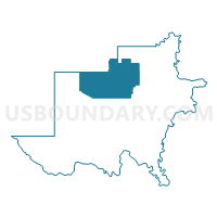
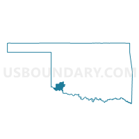
Voting District 23, Jackson County, Oklahoma
About
Outline

Summary
| Unique Area Identifier | 654145 |
| Name | Voting District 23 |
| County | Jackson County |
| State | Oklahoma |
| Area (square miles) | 94.44 |
| Land Area (square miles) | 94.39 |
| Water Area (square miles) | 0.05 |
| % of Land Area | 99.95 |
| % of Water Area | 0.05 |
| Latitude of the Internal Point | 34.67835150 |
| Longtitude of the Internal Point | -99.42863550 |
Maps

Graphs
Select a template below for downloading or customizing gragh for Voting District 23, Jackson County, Oklahoma


Neighbors
Neighoring Voting District (by Name) Neighboring Voting District on the Map
- Voting District 1, Jackson County, OK
- Voting District 105, Greer County, OK
- Voting District 106, Greer County, OK
- Voting District 13, Jackson County, OK
- Voting District 16, Jackson County, OK
- Voting District 17, Jackson County, OK
- Voting District 24, Jackson County, OK
- Voting District 4, Jackson County, OK
- Voting District 6, Jackson County, OK
Top 10 Neighboring County Subdivision (by Population) Neighboring County Subdivision on the Map
- Altus CCD, Jackson County, OK (21,958)
- Mangum CCD, Greer County, OK (3,613)
- West Jackson CCD, Jackson County, OK (2,043)
- East Jackson CCD, Jackson County, OK (2,018)
- Altus South CCD, Jackson County, OK (427)
Top 10 Neighboring Place (by Population) Neighboring Place on the Map
Top 10 Neighboring Unified School District (by Population) Neighboring Unified School District on the Map
- Altus Public Schools, OK (20,897)
- Mangum Public Schools, OK (3,583)
- Navajo Public Schools, OK (1,859)
- Blair Public Schools, OK (1,827)
- Olustee Public Schools, OK (723)
- Duke Public Schools, OK (664)
Top 10 Neighboring State Legislative District Lower Chamber (by Population) Neighboring State Legislative District Lower Chamber on the Map
Top 10 Neighboring State Legislative District Upper Chamber (by Population) Neighboring State Legislative District Upper Chamber on the Map
Top 10 Neighboring 111th Congressional District (by Population) Neighboring 111th Congressional District on the Map
Top 10 Neighboring Census Tract (by Population) Neighboring Census Tract on the Map
- Census Tract 9684, Jackson County, OK (5,795)
- Census Tract 9686, Jackson County, OK (4,669)
- Census Tract 9685, Jackson County, OK (4,117)
- Census Tract 9672, Greer County, OK (3,613)
- Census Tract 9681, Jackson County, OK (2,445)
- Census Tract 9683, Jackson County, OK (2,043)
- Census Tract 9687, Jackson County, OK (2,037)
- Census Tract 9682, Jackson County, OK (1,662)
Top 10 Neighboring 5-Digit ZIP Code Tabulation Area (by Population) Neighboring 5-Digit ZIP Code Tabulation Area on the Map
- 73521, OK (21,636)
- 73554, OK (3,614)
- 73526, OK (2,133)
- 73560, OK (829)
- 73532, OK (600)
- 73556, OK (166)